7 historic Phoenix landmarks that no one remembers
July 26, 2017 by
When the Central Avenue Dairy began in the early 20th Century between Central and 3rd Avenue, north of Thomas, the city limits for Phoenix ended at Van Buren.
They are all historic Phoenix landmarks. They were centers for the community long before Phoenix became the fifth-biggest city in the country. They have all been replaced by various commercial real estate projects, but they created memories for all who visited them. Here are seven historic Phoenix landmarks that very few people remember.
Weems Turkey Ranch
The ranch was built around the time Arizona became a state in 1912. It was surrounded by a six-foot granite wall. The ranch covered about 80 acres and was located at 7th Avenue and Camelback. It extended from 7th Avenue to 11th Avenue to the west and from Camelback to Colter to the north. The ranch house faced east and sat about 150 feet north of Camelback and 100 feet west of 7th Avenue. Weems had hundreds of turkeys and also had chickens, geese and goats. Most families in Phoenix at the time bought their Thanksgiving Turkeys there.
Today: The area is home to an LA Fitness, Fry’s and other retail shops and restaurants.
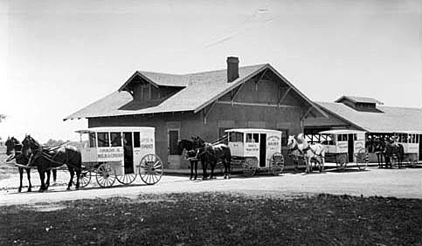
Central Avenue Dairy
The dairy began in the early 1900’s and ran from Earl to just south of Thomas and from Central to 3rdAvenue (about 46 acres). We never were bothered much by the smell as there were less than 100 cows at any one time.
Today: Park Central Mall construction began in 1955, thus ending the run for Central Avenue Dairy.Nearby land was also used to build St. Joseph’s Hospital and Medical Center.
Phoenix Trap and Skeet Club
Located in Echo Canyon at the base of Camelback Mountain, the Arcadia Neighborhood, it was an ideal place to be. The club was organized in the 1930s. In trap shooting, the“clay pigeons” are launched from a single machine away from the shooter. In skeet shooting, targets are launched from two machines in sideways paths that intersect in front of the shooter. The club hosted the world national competition for many years until 1952, when the club moved to Papago Park.
Milky Way Ranch
The ranch was a gorgeous place to visit — a giant oasis of 320 acres. It was located between 20th Street to 28th Street and from Camelback to Campbell. The ranch’s headquarters was located exactly where Trader Joe’s is today. The ranch was built in 1900 and closed down in 1950, but a nine-hole golf course was built on the site in late 1951.
Today: In 1965, Town and Country Mall was built and it has undergone renovations and a renaissance over the past several years.
Sportsman’s Park
Sportsman’s Park was a 160-acre horse racing track. It had a huge white sign with blue letters that rose high above the entrance at the northeast corner of 7th Avenue and Indian School Road. It extended east to 3rd Avenue and north to Indianola. The park was built in 1920. By late 1950, the racetrack closed its doors.
Today: The area is home to the entrance of the Melrose Historic District, a post office, fast-food restaurants and residential housing.
Cactus Air Park was an open area of 960 acres. There was always at least three to five airplanes sitting at the northwest corner of the field. The airplanes did not have a closed hangar. The area had no street signs until 1957. All of the 960 acres were hard flat dirt without a single growth of anything. This was due to the Borate compound the airplanes would spray on the field (Borate was later outlawed in the mid-1960s). The confines were Shea to Cactus to the north and 32nd Street to 44th Street to the east. Endless miles of desert extended beyond the confines.Cactus Air Park
Airhaven Airport
Airhaven Airport was built during WW II and was located between 27th Avenue and 35th Avenue just south of Indian School Road. The runway ran 30 degrees northeast to 30 degrees southwest. It was bordered on the southwest by Grand Avenue and the northeast by Indian School Road. The Arizona Canal bordered the airport to the south. The entrance was just before you got to the intersection of Indian School Road, 35th Avenue and Grand Avenue.