History of the North Central Phoenix Corridor
North Central Phoenix Corridor history begins with the development of the Central Avenue area in 1895 when William J. Murphy platted the Orangewood subdivision.
This two-square mile area bounded by what are now Northern Avenue and Bethany Home Road, between 7th Avenue and 7th Street, now simply referred to as North Central Phoenix Corridor, was promoted as the Orangewood Residential Village.
Murphy’s Concept
Murphy’s concept about Orangewood was to create a suburb of Phoenix “wherein might be established rural homes at an easy distance from the city.” He believed that the large lot size would attract upper income residents of Phoenix. From wealthy outside investors and immigrants who would utilize the lots to build large estate homes surrounded by citrus groves was his goal.
The Subdividing
The subdivision was divided primarily into 20-acre size lots with Central Avenue extending through the property as the subdivision’s principal roadway.
Olive and ash trees were added along both sides of Central Avenue. Also, citrus trees from Southern California were planted on the interior portions to make the subdivision more attractive to new investors and homeowners.
Exclusivity Was Planned
The exclusivity of Orangewood was evident in that at the turn of the 19th century. So, the Central Arizona Driving Association arranged to have Central Avenue deeded as a “driving street” for property owners to drive their horse-drawn buggies. There was even a separate path on the east side of Central Avenue for horses and riders only.
Evans Addition
North Central Phoenix Corridor history, keeping with the rural agricultural estate concept established by Murphy, J.M. Evans, platted and recorded “Evans Addition” to Orangewood in 1897.
Located directly south of Orangewood, Evans’ Addition was bounded by Bethany Home Road to the north, Camelback Road to the south, and 7th Street and 7th Avenue to the east and west. Also, the addition featured four large neighborhood blocks divided further into 20 smaller blocks.
Key Events in Development of the North Central Avenue Area:
- 1895 – Orangewood Subdivision platted by William J. Murphy.
- 1897 – Evans’ Addition to Orangewood platted by J.M. Evans.
- 1895-1910 – Central Avenue maintained by the Central Avenue Driving Association as a private road.
- 1910 – Maricopa County Board of Supervisors declared Central Avenue a public highway.
- 1911-42 – Orangewood and Evans’ Addition were subdivided into smaller five to fifteen acre tracts.
- 1920’s – Central Avenue paved with concrete as a 22-foot wide roadway.
- 1941 – Last of the original Orangewood lots were sold.
- 1940’s – North Central Avenue characterized by suburban home-sites on large, landscaped garden lots with substantial homes and estates.
- 1945-50’s – During the post World War II housing boom, large lots were further subdivided and developed with ranch style homes.
- 1948 – The horse path on the east side of Central Avenue officially named by the Arizona Horse Lovers Club as “Murphy’s Maricopa Bridle Path.”
- 1951 – Maricopa County Board of Supervisors extended the Bridle Path from the Arizona Canal to Camelback Road. Road widening in later years returned the terminus to Bethany Home Road.
- 1959 – North Central Avenue area annexed into the city of Phoenix.
- 1963 – Aleppo pines were planted to replace the original ash trees on Central Avenue.
- 1963 – Phoenix City Council rejected plans to bury the SRP irrigation lateral and widen the street declaring that Central Avenue should remain unchanged with its parkway character and the Bridle Path on the east side.
- 1972 – Responding to neighborhood objections, the Aleppo pines were replaced with ash trees. These trees still remain.
- 1977 – City Council Resolution 14895 was passed stating that the Bridle Path shall not be paved over with concrete or asphalt for new driveways to the residences.
1991-93 – Original William H. Brophy Estate, one of the last ten acre parcels in North Central Avenue area, redeveloped as La Reserve, a 36-unit gated residential project.
Architectural Character In North Central Phoenix
The architectural diversity of North Central Avenue contrasts with the uniform architecture found in newer developments being built throughout the city.
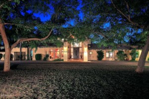
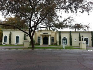
Central Avenue homes display a unique collection of architectural styles that use a wide range of building materials, textures and colors. Custom homes, some dating back to the early 1900’s, are interspersed throughout the area.
These reflect the original owners’ personal styles, the building periods and development trends, or mimic architectural styles found in other parts of the country.
Central Avenue and the Murphy Bridle Path
Central Avenue and the Murphy Bridle Path share in the history of the neighborhood and is listed in the City of Phoenix Historic Register. It’s also a Point of Pride for Phoenix. North Central Avenue has been a tree-lined street from the early days of providing an avenue for the Central Avenue Driving Club to today’s major arterial street from downtown Phoenix to the Sunnyslope area.
From Bethany Home to Northern Avenue, the street has four lanes of travel without a center turn lane. Rows of Olive and Ash trees line both sides of its right-of-way with the Murphy Bridle Path on the east, and a U.S. Bureau of Reclamation irrigation lateral on the west.
The Salt River Project maintains the irrigation lateral. The pavement edges taper to the landscape edges on either side of the street, and there are no curbs or paved sidewalks in the right-of-way, except at street intersections.
The Murphy Bridle Path Location and Features
The Murphy Bridle Path begins at Bethany Home Road and ends two-and-a-half miles north at the Arizona Canal. It is a well-graded pedestrian and bicycling trail approximately 10-feet wide, located between ash and olive trees.
Pavement intersects the trail only where streets and some driveways cross the path. Most adjacent property owners have not paved driveways across it in favor of keeping the path in a natural state. The bridle path has been a recreational path and landmark of North Central Phoenix for over 100 years.
The Historic Trees
The Olive trees (Olea europaea) that line Central Avenue are located outside of the public right-of-way on private property. These are the original trees planted by Murphy when the original Orangewood Subdivision was platted.
They lend both a historic value and character to the neighborhood and were planted sometime between 1905-1910. (Note: There are only two varieties of almost pollenless and fruitless olive trees that can now be legally grown in Arizona: Olea europaea ‘Wilson’s Fruitless’ or Olea europaea’s ‘Swan Hill.’ Nurseries in Arizona are prohibited from growing or selling olive trees that produce pollen and bear fruit.)
The Arizona Ash trees (Fraxinus velutina) located in the street right-of-way are not the original trees. The original ash trees planted in the early 1900’s were replaced by Aleppo pines in 1963.
These in turn were replaced by new ash trees in 1972 because the pines were not favored by the residents. Today, most of the ash trees are mature with large canopies. Those removed due to stress or disease have again been replaced with new ash trees.
The Irrigated Lots
The irrigation lateral, dating back to when Murphy first brought water to this area, remains an active lateral providing water to the irrigated residential lots in the North Central area.
The lateral is located between the ash and olive trees, and in some locations it remains an open ditch with natural or concrete edges. Driveway bridges provide access to the residences in these areas.
In other sections along Central Avenue, the lateral has been piped and is not visible. In June 2002, valley-wide survey by SRP identified the Central Avenue lateral as one of the oldest irrigation laterals in the city.
But, it was worthy of preservation. This was because of the historical context of where it is located as well as its public visibility, its condition, stable land uses surrounding it and other criteria.
Courtesy of the City of Phoenix, Planning Department 200 West Washington Street Phoenix, AZ 85003 (602) 262-7131

